Operational EO Ground Segment Solutions
We design and implement scalable ground segment systems that transform raw satellite data into trusted, analysis-ready products and operational geospatial services.
Discuss Your Mission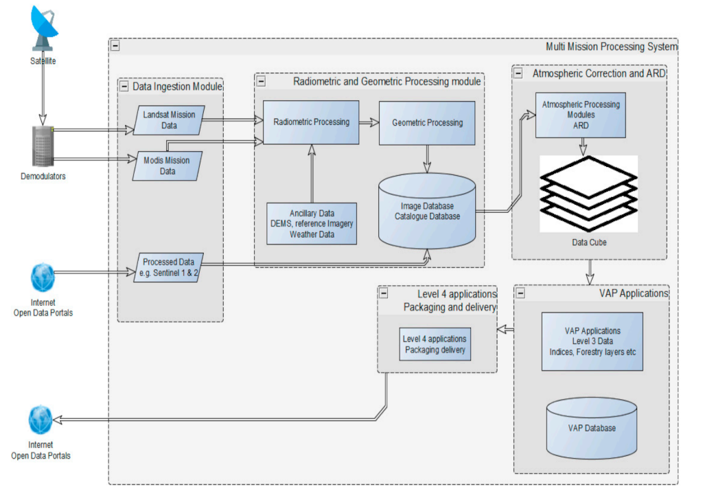
Reliable Earth Observation mission ground segment engineering.
Aphelion World develops mission ground segment solutions that support the complete lifecycle of Earth Observation data processing and distribution. Our systems are designed to handle ingest, correction, quality control, archiving, product generation and delivery workflows for operational satellite missions.
We help organisations move from raw satellite downlinks and fragmented processing chains to automated, scalable and operational EO data services capable of supporting national monitoring programmes, environmental intelligence platforms, disaster response systems and geospatial decision-support applications.
Core capabilities
- Automated satellite data ingest and processing pipelines.
- Radiometric, geometric and atmospheric correction workflows.
- Orthorectification, mosaicking and analysis-ready product generation.
- Quality assurance, metadata management and validation workflows.
- Operational archiving, cataloguing and data distribution systems.
- Integration with downstream GIS, analytics and decision-support platforms.
Why robust ground segments matter
Ground segments are the operational backbone of Earth Observation missions. They ensure that satellite imagery and derived products are processed consistently, validated correctly and delivered reliably to end users. Efficient ground segment workflows improve data accessibility, reduce operational delays and enable scalable national and regional monitoring programmes.
Our engineering approach
We focus on automation, scalability, reliability and interoperability. Our systems are designed around mission requirements, sensor characteristics, operational timelines and downstream product needs. We also support integration with cloud infrastructure, APIs, geospatial databases, web services and enterprise geospatial platforms.
Data Ingest
Automated acquisition and organisation of satellite imagery, auxiliary datasets and mission metadata.
Processing Automation
Repeatable and scalable processing chains for correction, calibration and product generation.
Quality Assurance
Validation procedures, consistency checks and traceable processing records for trusted products.
Distribution & Access
Product catalogues, archives, APIs and geospatial services for operational delivery and integration.
Whether you are establishing a new EO mission workflow, modernising an existing ground segment or building operational geospatial services around satellite data, Aphelion World can help deliver robust and scalable solutions.
Contact Us